“In an effort that could go down as one of the great feats in polar history, the American Colin O’Brady, 33, covered the final 77.54 miles of his 921-mile journey across Antarctica in one last 32-hour burst during which, without sleeping a wink, he became the first person ever to traverse Antarctica from coast to coast solo, unsupported and unaided by wind.”- NY Times
Start: Little Salmon River campsite
End: Seely Beach campsite
Mileage: 7.0 mi
Today’s map:
Hiking direction = from earplug right to left
Mark Shaw, AKA Bad Influence, posted this 2 minute drone footage that takes off from Goose Creek and then continues along the coast. Mark is a professional sound engineer who also owns and operates Trail Head Shuttle, a Vermont AT and Long Trail hiker shuttle service, and now is available for commercial drone work in real estate, 3-D mapping, via Skyview VT. It’s very informative about the breadth of some of these tidal crossings.
Mark and I joked about forgetting how challenging this trail really is, especially given the fact that we hiked it 10 years go. While he swears this is the last time on the FF for us, I started thinking how we might streamline a future walk along the coast, via engaging the drone to view any possible passage along the cliffed shoreline during low tides. Mark successfully put the drone up to get us out of a huge marsh that confounded us on the East Coast Trail in Newfoundland last summer. It’s like having s SUPER tall guide who can really view an obscure trail.
The unit is able to serve as an emergency locator and communication device. I entered in a few pre-set messages, essentially confirming that I was OK. I sent evening messages to both my wife and the shuttle operator with a map pinpointing the location of our campsites, along with GPS coordinates. I have added the unit to my day hikes. When I find myself injured and need of assistance, I should be able to get help. I believe it is an essential part of my kit, particularly when I am guiding clients in the wilderness. There was very spotty cell service available on this hike. I pay $12 a month for the service, which can be turned off for any months where travel might not occur.
It rained yesterday and rained today as well. With the very high humidity the first two days, we were forced with the very unwelcome situation of donning cold wet socks, footwear, and clothing each morning. I’m in the habit of leaving any spare clothes home these days, in an effort to reduce my pack weight. I do carry a dry set of sleep wear on all my hikes, that allows me to be very comfortable when it’s time to sleep.
One tip that I can offer the wet hiker is to put on a wind shirt or light synthetic jacket over your wet shirt when you reach camp. If you are fortunate enough to have found clothing that is truly breathable, your body heat dries out the wet clothing in an hour or two. I have had great success with Patagonia’s Houdini windshirt and their 10 oz. Nano-Air Light Hoody. The Hoody was developed to pass copious amounts to perspiration while at the same time providing adequate insulation for winter use. I have been amazed at the width of the range of temperatures that I wear the Hoody, from winter biking in freezing conditions to summer evenings. I like the blaze orange version for visibility.
If your clothing is not totally sopping wet, it can also be dried by wringing it out and putting in on top of your sleeping pad and under your sleeping bag where your body heat drys it out overnight.
“Aires ( March 21-April 19). To get where you want to go, you’ll have to make your way through the crowd. Start moving and people will get out of your way. Movement is what makes things change.”- Daily Horoscope-Holly Mathis, 6/25/2018
Nature is ahead of me on this one. Somehow, in a surprisingly short amount of time, the vista outside of my big kitchen window is a mass of slowly expanding movement of green: my lawn, the hay fields all around me, and the three hundred and sixty degree panorama of forest that surrounds our house.
My ever-expanding vegetable garden is fully planted and growing steadily. I’m already harvesting lettuce, green onions, beet greens, parsley , and celery. Unfortunately the deer are also moving in to eat my plants, and I plan to install my electric fencing tomorrow after this rain lets up.
Bugs are moving. I’ve pulled out one tick and plucked off a dozen already. Did you know that tics are blind, and detect animal hosts through body odors, breath, heat, movement and vibrations?
I’ve got a few mosquito bites decorating my neck. I’m not much bothered by mosquitoes after experiencing the massive numbers of them in Labrador on several of my motorcycle and canoeing trips there over the years. Its all relative.
On thing that has assisted me in maintaining a level of activity that has kept my weight down, and in shape for backpacking is setting movement goals. I have two: biking 1,000 and walking 1,000 miles a calendar year.
I monitor my movement progress through the use of the Strava app, where one of the functions allows users to view distance totals by sport on their Profile page. As of today, I am 26 miles ahead of my biking pace
but 52 miles down on walking.
I plan to get moving on this by doing several two-hour hikes this week to climb back to hiking pace.
Lifestyle changes matter. People who live in cities often walk more daily miles than us country residents, where services are too far away to access without driving a vehicle.
Looking for ways to move that are functional helps. For example, I amassed 17,369 steps (8.4 miles via Fitbit) last Friday where I spent the better half of the day tilling, planting, weeding, fertilizing, mulching, and watering the veggie garden.
When it stops raining today, I plan to fire up my little tractor and attach a cart and move down to the woods where I have stacks of unsplit rounds that I’ll haul up to the wood shed to split and move under cover for heating the house this winter. I still cut my own firewood which leads to all sorts of strength, twisting, and core work.
This afternoon I plan to walk thee miles to my friend Dave’s house in Lincolnville Center where I’ll cop a ride to my weekly Men’s Group get together.
But I’ll be competing for a place on the path with the ticks, who will be waiting for me as I walk through the unmown hayfield and the brush that is filling up the abandoned Proctor Road as I move my way down to the pavement of the Heal Road that will lead me to open space walking to the Center. I plan to wear long pants, sprayed with Permethrin and hope for the best.
The solstice passed on June 21. Winter is coming. Get moving !
This past weekend I was one of the 70 or so folks that came to Hood River, Oregon to witness the marriage of The Mayor and Genius.
In 2010 I walked the Pacific Crest Trail with them for five months. I last saw them on June 16, 2017 in Hallowell, ME for lunch where they made me promise to keep quiet with the announcement that they had just become engaged.
Big News!
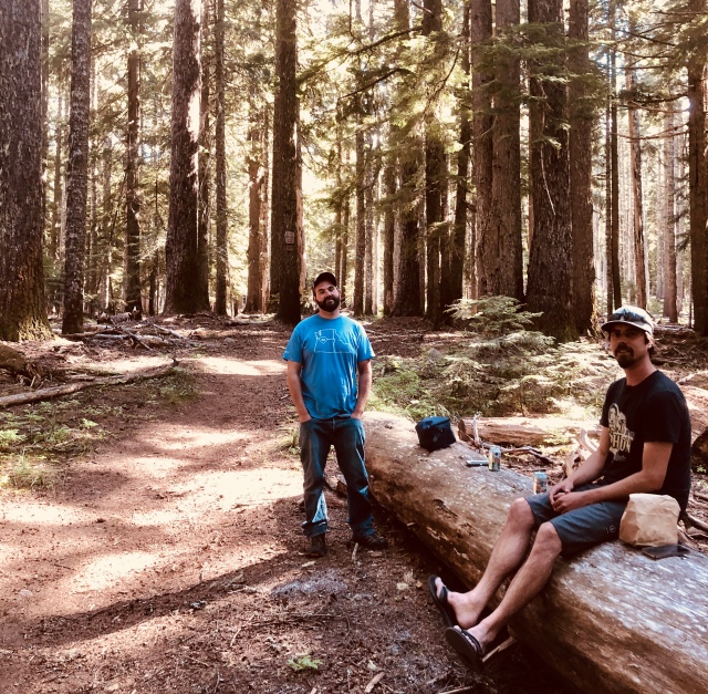
I’m here in a rural AirB&B cabin rental for a few nights in Washington, beside Buck Creek, just north of the Columbia River with my fellow Triple Crown hiker Axilla and Train, who joined up with Megatex on our 2010 thru hike of the PCT.
Buck Creek cabin
When Train heard that three of the MeGaTex posse were pulling together again to attempt a Continental Divide Trail thru-hike in 2013, Train fired up his interior locomotive and became a driving force of movement and good judgement that assisted the gang in emerging from that graduate-school-level of hiking with our souls and bodies battered, wizened, but more importantly, transformed into the fully functioning human beings that we are today.
Uncle Tom, Dick Wizard, Trail, and General Lee- April 2010
My other Triple Crown partner on all thee of the major US National scenic trails is Dick Wizard, Mayor’s older brother, who is staying across the Columbia River with his most excellent wife Emmie and their families.
We spiffed up pretty well for the wedding. I need to buy a suit.
Wizard, Me, The Mayor, Axilla, and Train
We were thrilled to hike from Government Camp on the PCT today.
This area remains startlingly beautiful.
Axilla and Train on PCT – June 17, 2018
Stepping off the trail, I could not pull myself away from studying the thick shingles of bark on an ancient, giant evergreen of some west-coast type that was adorned with psychedelic colors of orange and green mosses, with clumps of lichen moving about a bit in the occasional gust of wind.
When I last passed though the PCT here, I stopped on a hiking break for trail magic, provided by Water and Bucket, two folks I hiked with for a bit on the Appalachian Trail in 2017. They fed us up and also supplied a few of the renowned Oregon microbrews. We visited them and their new baby, Ren, yesterday at their new house.
Old hiking friends remain close, even after years of physical separation. Living outside for months at a time as a part of a group does it to you, if you are fortunate to find the right group.
I’m spending a week in Disney World where I’m sharing a tent site at Fort Wilderness Campground. I was in shirt sleeves and shorts yesterday and racked up 13 miles of walking on day 1 and 10 more on day 2. I’m hanging with my best friend, Edward, who lets me stay at his campsite here any time for as long as I want and he won’t take any $$ from me. Of course, I have have no rental car.
Edward checks out my new tipi
Edward has been here from November and will stay until early March, as he has done for every single winter for the last 40 years. When March comes, he’ll head back to his fruit and vegetable farm in Masschusetts where a 100 hour per week schedule awaits him for the rest of the calendar year.
I ‘m testing out a brand new tent, made by SeekOutside. It is 6’10” high and 12′ in diameter, weighing in at 4 and a half pounds. There’s just a single telescoping carbon fiber pole. Here is a a picture of the unit from Seek Outside set up with interior heat with a titanium stove and stove pipe, probably somewhere during elk hunting season in the Rockies.
-Seek Outside 12′ tipi
From the website: “The Four-Person Tipi is roomy and storm worthy. Extremely lightweight for the square footage, this tipi is a palace for solo use. It is capable of sleeping up to four with minimal gear, but is better suited to the luxurious solo trucker, or for two with late-season or winter gear. Handmade in Grand Junction, Colorado, the tipi features: Dual zipper doors with storm flaps, Single peak vent, stove jack with rain flap, 6 inch sod skirt with rain flap, ultra robust stake loops, interior hang hoops for tying clothes line for hanging gear, and external guy-out loops to steepen walls, or pitch the shelter down in tight spots.”
I am awaiting shipment of a custom titanium stove and stove pipe from Don Kivelus, owner of Four Dog Stove out of St. Francis, MN.
I have been using one of Don’s full size titanium stoves for 15 years of winter camping and it is still like new. The big stove pairs with with a much larger, custom 9 x 12 foot Egyptian cotton wall tent that stands 7′ high. It easily houses 4 winter campers and all gear.
This tent is targeted for personal use, and will hold only one more camper and all the accompanying gear in winter. I plan to experiment with this tipi and stove later this February on a multi day winter camping trip in Acadia National Park. If everything works out, I should be able to transport the tipi and stove on racks bolted to the rear of my Surly Pugsley fat tire bicycle and embrace winter riding and camping in style.
3/17 trip into Katahdin Woods and Waters National Monument
I plan to devote several blog posts to presentations from the 2017 Snowalkers Rendezvous in Fairlee, VT. The quality of the presentations is top notch, with several giants of northern adventuring in the line up. Here is the first:
David Pelly- “How Inuit Find Their Way – Navigation in the Trackless Arctic”
Canadians were well represented at this year’s SnowWalkers Rendezvous.
David presented leadoff slides of traditional Inuit tattoos. In 1982 David moved to Baker Lake, Northwest Territories, Canada, where David eventually learned to speak Unuit.
As examples of superior navigational abilities, David shared with us observations about the uncanny ability of a native named Tulurialik to discern from thousands of small piles of snow out on the tundra one that held a fox trap. David shared with us another story about traveling with Tulurialik on a snowmobile in complete white-out conditions where Tulurialik reoriented a snowmobile’s direction after recognizing a tiny protruding rock as a feature he remembered from passing through the area previously.
Possessing superior visual acuity, the Unuit subsistence hunter’s observations were fundamental to their survival. Men were raised as hunters and were usually taught by their grandfathers. They studied cloud masses and colors, indicating the location of distant land masses. Snow ridges reflect wind directions that offer clues to direction of travel on snowmobiles. Directions for wilderness travel as long as 200 miles are commonly transmitted orally, without maps. Mapping in the Inuit way is extremely sparse compared to the expanded view of modern maps. Descriptive place names and stories are techniques that increase the memory of a path of travel. Proportions do not matter- what matters are the indications of water borders (bodies of water).
As part of the presentation, David displayed a hand-drawn inuit map with minimal lines that looked nothing like I had ever seen.
“ I could actually do a whole half hour talk about this hand drawn simple map,” he said.
David’s talk was bittersweet, as things for the Unuit have dramatically changed for this culture, even in the past 15 years. I encourage the reader to check out the charitable foundation headed by David Pelly in the memory of his 20 year old adopted Inuit son, Ayalik, who had died unexpectedly in his sleep. Money from the foundation supports sending Unuit youth from Nunavut on extended outdoor adventures throughout North America. www.AyalikFund.ca
With half of 2017 gone, there are six months of adventures still available for the rest of year. Here’s what’s on my plate right now:
Finish up writing my first book!
I have completed the writing and the editing process for In The Path of Young Bulls: An Odyssey on America’s Continental Divide Trail.
Train, General Lee, Dick Wizard, Breeze CDT 2013
My CDT Trailjournal has logged 275,000 web visits to date. The book is completely revised version of my 2013 Trailjournal, adding new historical material and dialogue. I’ve scheduled a design meeting with the publisher tomorrow to discuss selecting the color photos for the book. I plan for 30 pages of photos, and have been going through thousands of them in the past two months. We’ll be discussing fonts, graphics, and map placements. Copies of the manuscript are already out for final checks as well as possible endorsements. If all goes as planned, the book should be out by Sept. 1. It will be carried on Amazon, and will go into a Kindle version as well. Stay tuned!
Complete my recovery from my May 22 accident while descending the Bigelow range.
The real deal
I’m 95% through rehab on a torn hamstring and severely bruised back. Riding my mountain bike is better for me than hiking now. I have to take care not to overextend the range of the hamstring.
Prepare for my Aug.6 presentation at THE 41st APPALACHIAN TRAIL CONSERVANCY CONFERENCE– AUGUST 4 – 11, 2017 AT COLBY COLLEGE | WATERVILLE, MAINE
I’ll be giving a Sunday morning presentation (W0613)- Why Walking Matters: Benefits of Walking/ Improvisational Skills in Long-Distance Hiking.
“Tom Jamrog, Triple Crown thru-hiker, author, and Maine Guide with Uncle Tom’s Guided Adventures. From the ages of 57 to 63, “Uncle Tom” thru-hiked four National Scenic Trails. Tom reviews the latest research on the physical and mental health benefits of walking, and discusses physical training and mental techniques that can bolster an aging hiker’s continued success on the trail.”
Hike a new trail in Newfoundland. -Private Trip- August 8-25
Newfoundland’s East Coast Trail is “One of National Geographic’s Ten Best Adventure Destinations in the World”
East Coast Trail- Newfoundland
From the East Coast trail Association’s web site:
The East Coast Trail unites 26 wilderness paths, along 108 miles of North America’s easternmost coastline. The paths of the East Coast Trail take you past towering cliffs and headlands, sea stacks, deep fjords, and a natural wave-driven geyser called the Spout. Experience abandoned settlements, lighthouses, ecological reserves, seabird colonies, whales, icebergs, the world’s southernmost caribou herd, historic sites, a 50-metre suspension bridge, two active archaeological dig sites, and many more attractions.
Guide a trip of The Whole Hundred ! (Abol Bridge->>Monson)
September 1-10— SOLD OUT
Maine’s Hundred-Mile Wilderness is a huge, largely uninhabited region, beginning on the outskirts of Monson, ME. Many thru-hikers consider Maine the best part of the whole 2,200 mile Appalachian Trail. The Hundred Mile Wilderness appears on many hiker’s Bucket List. This southbound trip will take place over 9 nights and 10 hiking days, allowing for ample time to settle into a comfortable schedule. We will take advantage of a mid-point resupply service, so that we will not need to carry food for the whole 10 days. This trip is suitable for a hiker who is able to carry 30 pounds on a 10 mile average per day. We’ll stay in lean-tos, and/or tents, space permitting.
Price Includes: -Ground transportation from Lincolnville ME, mid-point resupply cost (you provide the food, etc.) packing list, and on-trail skills instruction. Meal assistance is available by arrangement.
-Up to 2 hours of pre-trip preparation consultation (via phone) is provided to participants. Group size is limited to 4.
19th Annual Winter Camping Symposium-Oct 26 -29, 2017. YMCA Camp Miller, 89382 E Frontage Rd, Sturgeon Lake, M.
23rd Snow Walkers Rendezvous -November 10-12, 2017 at the Hulbert Outdoor Center in Fairlee, Vermont.
Includes presentations, workshops, information about wilderness trips and amazing food! Participants may choose to stay in cabins, tents or commute to the event. I hope to offer a new presentation: Winter Fat Tire Biking/Camping in new Maine’s Katahdin Woods and Waters National Monument.
Despite being the only guest in the Mount Chase Lodge last night I was served a most excellent breakfast at 7:30, the time of my choice. Sky prepared pancakes, fruit slices, and bacon from a pig that had secured full employment here, on table scrap duty this past season. Fresh coffee, home made muffins and a fresh fruit bowl rounded out the meal.
Smilin’ Sky’s the guy
I was more than willing to take up Sky’s offer of leftover bacon and last night’s brisket. At two degrees outside, I was not concerned about food spoilage.
I’ve waited for this winter bike camping trip for a long time. My last bike packing trip was in 2012 on the Sunrise Trail when I joined my neighbor and biking pal Andy Hazen on a stretch from Ellsworth toward Cobscook Bay. You can check out that most interesting bikepacking trip here.
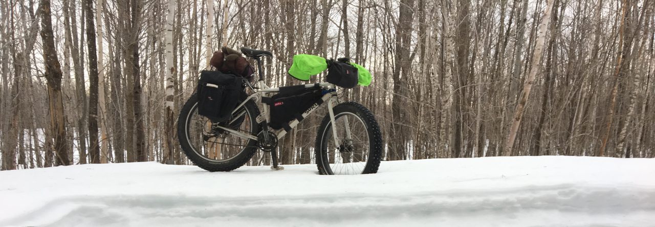
I have that same Surly Pugsley now. It was the perfect choice for these two pristine winter biking days.
Rollins Trails/ Ragged/Snow Bowl
It’s a fat tire bike, with 4 inch wide tires, inflated to 7 pounds of pressure, enabling the wide footprint to track easily over this packed groomed snow.
It is a 15 mile ride directly west over a roller coaster of a tarred road from Mt. Chase Lodge to the parking lot for the Monument.
Ask the staff at the Lodge about the signage that marks the left turn after the bridge over the Penobscot River just before the end of the pavement. A short drive down a plowed gravel road leads to a small parking lot where the winter trail begins.
I parked right next to Guthook’s VW, as we were the only visitors here for these two days.
The map on the KWWNM website is detailed enough to be all you’ll need. One caution-print your own copy in color. Mine was in gray scale. I would have been easier to navigate if my map was color coordinated with the red, orange, yellow, and blue triangles marking intersections and trails.
With my parking pass visible on the dashboard, I unloaded the bike from inside my Honda Element and took off, smiling from ear to ear at the superb condition of the surface beneath my wheels. Access to trails and these huts is free of charge, however, overnight use requires reservations.
Hard to tell if smiling !
There hasn’t been any fresh snow here for more than a week. KWWNM’s snowmobiles tow dedicated groomers that have packed the trail! There were two faint cross country ski grooves that I stayed out of, preferring to ride to the side of the fresh snowmobile track.
The surface was not at all icy, but composed of groomed snow that refroze into a decent grip of a track.
This screen shot of my Strava feed summarizes my mileage, speed, and moving time. It was a relatively quick 10 mile ride into Big Spring Brook Brook Hut.
Here’s the elevation profile.
There were three parts to this ride.
The first was four miles over relatively flat terrain on the Messer Pond-Orrin Falls Road, an old logging path eventually passing through a summer gate leading to Haskell Hut on the shore of the expansive Haskell Deadwater.
Overflowed stream beside winter trail
Haskell Lodge is only a tenth of a mile off the trail and is worth a rest stop.
It is the smaller of the two cabins that are options for your over night in The Monument. The doors are unlocked, but day users are asked to refrain from using the propane cook burners, lights, and firewood.
These are community huts, where everyone is welcome up to the maximum number of sleeping platforms and reservations are required.
Next, I rode along the edge of the Deadwater where I made a brief stop at the spectacular view at Haskell Rock Pitch. I heard it well before I saw it. Impressive!
From there the trail enters thicker, older forest for almost a mile when you reach a fork. With the spring melt down, extra caution is advised with regards to deep meltdown holes on the bridges and sections of deep animal tracks on the trail.
This is dangerous:
The riding is fast and the setting is isolated.
The last segent starts with a right on the blue diamond trail for three more miles or so out past Little Messer Pond where the path ascends to a high point on 900 feet.
You will know a turn is coming when you pass over a flowing stream up high and then see the signage pointing left for the 0.3 mile descent into Big Spring Brook Brook Hut.
Big Spring Brook Hut
It took me two hours to cover the 10 mile distance, which included stops for photos, and my snack break at Haskell Hut. Guthook skied in earlier, pulling a plastic sled that was loaded with 5 days worth of food and gear. It took him 5 hours. Fat bikes shine under these travel conditions.
Big Spring Brook Brook Hut is appointed with basic pots and pans, and is heated with a wood stove with drying racks above for hanging wet clothing.
Water in drawn from the stream in front, with an outhouse out back. There is a large sleeping loft as well and half dozen wooden sleeping platforms on the first floor. The capacity of his hut is listed as sixteen.
Guthook and I combined forces to come up with a superb one pot supper. I added Mt. Chase Lodge’s bacon and brisket to his tortellini, cheese, and tomato sauce.
This trip was brief but rewarding. I spent one night sharing the Lodge with Guthook, who was bushwhacking round the area on several long day hikes.
The snow was solid enough that you could walk anywhere, and with no leaves on the trees your line of sight is immeasurably better in the winter than in the summer when the green word covers all. It was a most satisfying and unique experience for us to warm ourselves by the glowing embers of the stove as we pondered the vast wilderness surrounding us.
I joked with Guthook that we finally made time to do nothing.
We were the only people spending our time within this 87,000 acre National Monument. God bless America!
And I thank you, Roxanne and Lucas, for allowing me to have this unique place to explore for the rest of my life !
The staff at Mt. Chase Lodge are knowledgeable about current trail conditions and travel within The Monument. They are ready to serve as a launch point for your own adventure. Information and Reservations: (207) 528-2183